I wanted to do this post near the same time as the summer solstice in the northern hemisphere, June 21, the longest day of the year, but decided to do it a little early. I previously posted on solstices and equinoxes here. On Athas, the summer solstice is also the first day of the year according to the most common calendar throughout the Tablelands. This day is Dominary the 1st and is referred to as the Highest Sun. It is the day the sun is in the sky longest and it is also the day the sun reaches its highest point of the year. Learn more about the solstice here
Athas revolves around its sun once every 375 days. The sun is highest in the sky on Dominary first and then after that day the sun will be lower and lower in the sky each day until it reaches the winter solstice, or Lowest Sun, which occurs on Morrow the 3rd, exactly half way through the 375 day cycle. Or 187.5 days later. After that day the sun will gradually begin to climb in the sky reaching higher and higher at its zenith at noon until it hits Highest Sun again. (Please do not think that Low Sun will be hotter because “the sun is lower and thus closer to the planet’s surface, like if I get closer to a fire I get warmer” That is WRONG! It has to do with the angle of incidence - a topic for another day.
I recently learned about a method of filming the path of the sun on a daily basis to plot the movement of the sun against the sky through the year. This is called solargraphy. It’s typically done over several weeks or months with a pinhole camera pointed toward the direction of the sun. The result will plot the course of the sun in the sky. If started on the summer solstice and ended on the winter solstice you will get a neat plot of each day with the sun’s position clearly marked. Different latitudes will provide different arcs in the image. This short news clip video here explains it pretty well in just two minutes.

All in all there are some amazing images that are captured using this method. I recommend you google “solargraphy” and check out some more. There is still time to get your pinhole camera build and in place before the solstice so you can get six months worth of images. You will want to start it by June 21st to get the full effect.
You can imagine what this would look like if done on Athas and it gives you a better idea of what Athasians would understand as High Sun and Low Sun.
There are some pretty simple equations to calculate the position of the sun at varying latitudes for the solstices and equinoxes. You just need two pieces of information: your latitude and your planet's tilt.

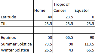
We can do a similar thing for Athas. We don't know the tilt, but for argument's sake let's assume it is roughly half of Earth's tilt, or 12 degrees. Which contributes to its hotter climate. This places the Tropic of Balamarash at 12 degrees North and again for argument's sake let's say the Tyr region is at the 20 parallel to the north. This will keep the High Sun and Low Sun still discernable, but just not as extreme as what we have on Earth.

If Athas didn’t have a tilt of any kind there would not be multiple curves of varying height throughout the year but just one curve the sun travels along each day that matches the equinox curve.
If the tilt of the planet Athas was less than Earth’s ~23.5 degrees the distance between the highest and lowest arcs would be tighter. (For comparison Mars’ tilt is ~25 degrees and Venus’ is ~3 degrees.)
Imagine that pattern of curves permanently fixed in the sky to the south from where you live. (Assuming you live north of the equator). If you were to continuously travel south along the globe (because Athas, like Earth is roughly a sphere, not a disk) that pattern would get higher and higher in the sky, the curves would start to straighten out and go more directly from east to west to where the high sun point is directly overhead at noon on the summer solstice at the Tropic of Cancer (The 23.5th degree north latitude) As you continue south towards the equator the entire pattern moves overhead to where the “high sun” curve is now in the north sky, and the ”low sun” curve is in the south sky. Then at the equator during the equinox, the sun is directly overhead at noon.
If the events of Athas happened at the equator the sun would be directly overhead at noon on the equinoxes. This means that the solstices would fall equal distance to the North or South from directly overhead. There would be little ability to discern which was “summer” and which was ”winter”, implying that instead of having a High Sun and Low Sun you would have "North Sun" and "South Sun" that corresponded to the solstices.
If the events happened between the equivalent of the Tropic of Cancer and the equator you would have to look slightly North of directly overhead at noon to see “high sun”. Then Sun starts to lower slightly to the north. it wouldn’t necessarily be the on Dominary 1 that the sun is directly overhead.
If the events happen too far north or south you could get a day that the sun would not set completely on the summer solstice or a day it would not rise completely on the winter solstice.
Based in this information I make the following conclusions.
Athas is a planet roughly the shape of a sphere, Similar to Earth.
Athas has a tilt. It’s unknown how much, but it’s enough that it’s noticeable to distinguish between summer and winter solstices and create a a discernable "Lowest Sun" and "Highest Sun" in the skies.
The Tyr Region does not lie at the equator.
The Tyr Region most likely lies north of the equivalent of the Tropic of Cancer. - Tropic of Balamarash we’ll call it. Or possibly south of the equivalent of the Tropic of Capricorn - Tropic of Tasker we’ll call that one. This is strictly based on the observation of Highest Sun and Lowest Sun.
Personally, I like to believe it lies to the north, I may be persuaded otherwise if something were to turn up to convince me. But you can put your Tyr Region anywhere you like. I don't think the original authors deliberately put the Tyr Region in the north there, but unintentionally placed it there based on writings and art from their own biases and familiarity with Earth and living in the northern hemisphere. However, I cannot find any canonical references that indicates one way or another. A simple “Rikus looked south of Tyr toward the oncoming horde. He lifted his hand to shield his eyes from the sun before him” would be enough.
Ask your players if their character is facing south at noon if the sun is in their eyes or at their back or directly overhead. They probably have their own biases based on where on the globe they live.
And finally, some questions for all my fellow Athasians mapping the surface of Athas.
Where is the Tyr region?
Where is the equator?
Where is the Tropic of Balamarash?
And where is the Tropic of Tasker?
Hopefully this provides some insight into Athas, its sun, and the location of Tyr.


No comments:
Post a Comment